


6 LA PESSE / COL DE CUVERY

DANCHAUD
User
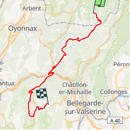

Length
50 km

Max alt
1332 m

Uphill gradient
1332 m
Km-Effort
67 km

Min alt
499 m

Downhill gradient
1317 m
Boucle
No
Creation date :
2014-12-10 00:00:00.0
Updated on :
2014-12-10 00:00:00.0
--
Difficulty : Difficult

FREE GPS app for hiking
 SityTrail
IGN / Geographical institutes
SityTrail Plus
The world is yours!
About
Trail Mountain bike of 50 km to be discovered at Bourgogne-Franche-Comté, Jura, La Pesse. This trail is proposed by DANCHAUD.
Description
6 eme ETAPE DE LA GTJ
Positioning
Country:
France
Region :
Bourgogne-Franche-Comté
Department/Province :
Jura
Municipality :
La Pesse
Location:
Unknown
Start:(Dec)
Start:(UTM)
719377 ; 5129714 (31T) N.
Comments